Close Menu
Terrain News
  • Environmental Science
  • Landforms & Habitats
  • Extreme Events
  • Watershed Restoration
  • Wildfire
What's Hot

Columbia County Secures Grant for Watershed Restoration

Cyprus Hosts Successful Hackathon Spotlighting Innovative Wildfire Solutions

Farmers Insurance Proposes 7% Rate Increase While Committing to 5% Policy Growth in Wildfire Areas

Facebook X (Twitter) Instagram
Facebook X (Twitter) Instagram Pinterest
Terrain News
TerrainWorks
  • Environmental Science
  • Landforms & Habitats
  • Extreme Events
  • Watershed Restoration
  • Wildfire
Terrain News
You are at:Home»Watershed & Environmental Science»GIS-Driven Soil Loss Assessment and Watershed Prioritization for Effective Land and Water Conservation
Watershed & Environmental Science

GIS-Driven Soil Loss Assessment and Watershed Prioritization for Effective Land and Water Conservation

Terrain NewsBy Terrain NewsJanuary 30, 2025072 Mins Read
Share Facebook Twitter Pinterest LinkedIn Tumblr Email
Gis Driven Soil Loss Assessment And Watershed Prioritization For Effective Land
Share
Facebook Twitter LinkedIn Pinterest Email

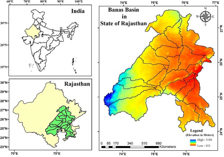
The article discusses the critical issue of land degradation and soil erosion, particularly in the Banas River Basin in Rajasthan, India, which affects agricultural productivity and food security. Land degradation globally impacts crop yield, causing significant economic losses, especially in Asia. In India, soil loss from erosion is predominantly driven by rainwater and wind, contributing to decreased GDP and increased poverty.

The study employs the Revised Universal Soil Loss Equation (RUSLE) integrated with Geographic Information Systems (GIS) and remote sensing to assess soil loss in the Banas Basin. The region is vital due to its diverse climate zones and reliance on its seasonal river. The methodology includes the derivation of several factors affecting soil erosion, such as rainfall erosivity, soil erodibility, and land cover.

Results reveal significant soil loss across various watersheds within the basin, with the highest erosion rates found in locations where land use practices change abruptly and where slopes are steep. The study categorized soil loss severity and prioritized watersheds for conservation practices, emphasizing the need for targeted intervention in the most affected areas to mitigate water erosion.

The findings highlight the importance of integrating advanced modeling techniques for efficient soil loss estimation and planning conservation measures, ultimately aiding policymakers and land planners in sustainable land and water resource management.

Source link

Assessment Conservation Effective GISDriven Land Loss Prioritization Soil Water Watershed
Share. Facebook Twitter Pinterest LinkedIn Tumblr Email
Previous ArticleEnhancing Tsunami Readiness in a Changing Climate
Next Article Yoshiki Contributes $500K to Support LA Wildfire Relief
leebenda
Terrain News
  • Website

Related Posts

Columbia County Secures Grant for Watershed Restoration

November 27, 2025

Understanding PFAS Pollution: Key Findings from the Potomac River Watershed Study

November 25, 2025

Three Hope-Solebury Students Receive Watershed Scholarships

November 24, 2025
Top Posts

Harnessing Machine Learning to Enhance Extreme Weather Alerts

January 8, 202519 Views

Steamboat Secures $5 Million for River Revitalization

January 25, 202517 Views

Understanding Extreme Weather: The Link to the Climate Crisis

January 8, 202515 Views
Stay In Touch
  • Facebook
  • YouTube
  • TikTok
  • WhatsApp
  • Twitter
  • Instagram
Most Popular

Harnessing Machine Learning to Enhance Extreme Weather Alerts

January 8, 202519 Views

Steamboat Secures $5 Million for River Revitalization

January 25, 202517 Views

Understanding Extreme Weather: The Link to the Climate Crisis

January 8, 202515 Views
Don't Miss

Columbia County Secures Grant for Watershed Restoration

Cyprus Hosts Successful Hackathon Spotlighting Innovative Wildfire Solutions

Farmers Insurance Proposes 7% Rate Increase While Committing to 5% Policy Growth in Wildfire Areas

Popular This Week

Global Cost of Natural Disasters Surpasses $250 Billion in 2023, Reports German Insurer

App Tool Measures Pesticide Toxicity Levels

Killeen Celebrates Bravery of Firefighters Who Aided in California Wildfires

© 2025 Terrain News. All Rights Reserved.
  • About Us
  • Privacy Policy
  • Terms and Conditions
  • Disclaimer

Type above and press Enter to search. Press Esc to cancel.