Close Menu
Terrain News
  • Environmental Science
  • Landforms & Habitats
  • Extreme Events
  • Watershed Restoration
  • Wildfire
What's Hot

Creating a Swift Wildfire Response Standard

Ohio River Basin Restoration: A Collaborative Action Plan Unveiled

Evacuation Alerts Issued as Gilmore Trail Fire Expands Near Fairbanks

Facebook X (Twitter) Instagram
Facebook X (Twitter) Instagram Pinterest
Terrain News
TerrainWorks
  • Environmental Science
  • Landforms & Habitats
  • Extreme Events
  • Watershed Restoration
  • Wildfire
Terrain News
You are at:Home»Watershed & Environmental Science»Mapping Alpine Snow Depth and Volume Using Aerial Imagery Techniques
Watershed & Environmental Science

Mapping Alpine Snow Depth and Volume Using Aerial Imagery Techniques

Terrain NewsBy Terrain NewsApril 2, 2025002 Mins Read
Share Facebook Twitter Pinterest LinkedIn Tumblr Email
Mapping Alpine Snow Depth And Volume Using Aerial Imagery Techniques
Share
Facebook Twitter LinkedIn Pinterest Email

In mountainous environments, traditional methods for measuring snow depth and snow water equivalent often fall short due to limited spatial coverage, especially in high elevations and remote areas. This article discusses the use of Structure from Motion (SfM) photogrammetry as an innovative approach to enhance snow depth mapping by utilizing images captured from aircraft. It highlights successes from the Airborne Snow Observatory (ASO), which combines lidar data and imaging spectrometry for accurate snow measurements.

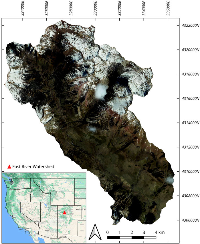
The study focuses on evaluating SfM’s ability to estimate snow depths using high-resolution RGB photographs in comparison to established lidar-based methods. Conducted over the East River Watershed in Colorado, the analysis involved capturing snow-on and snow-free imagery, alongside lidar data for ground truthing. The results indicated that while SfM can capture snow depth effectively in open areas, challenges remain in regions with vegetation and steep slopes. Nonetheless, the SfM technique achieved promising accuracy, comparing favorably to lidar outputs with a relatively low normalized median absolute difference.

Overall, the findings suggest that SfM could serve as a supplementary method for large-scale snow observation, particularly where lidar is not feasible. The technique shows potential for continuous snow depth monitoring and can aid in hydrological modeling, offering a scalable solution for water resource management in mountainous catchments. Future research may focus on expanding the use of SfM across different terrains and conditions to refine its efficacy and integration into operational frameworks.

Source link

Aerial Alpine Depth Imagery Mapping Snow Techniques Volume
Share. Facebook Twitter Pinterest LinkedIn Tumblr Email
Previous ArticleAddressing the Ripple Effects of Extreme Weather and Climate Change: Insights from the Multi-Hazard Early Warning Conference
Next Article Innovative Sandbox Technology Enhances Wildfire Training for Colorado Firefighters
leebenda
Terrain News
  • Website

Related Posts

Chesapeake Bay Report Card Highlights Decline in Health for 2024

June 12, 2025

Explore Watershed Science with Union County and AmeriCorps

June 5, 2025

Inspiring Watershed Learning for Future Generations

June 1, 2025
Top Posts

Harnessing Machine Learning to Enhance Extreme Weather Alerts

January 8, 202515 Views

Understanding Extreme Weather: The Link to the Climate Crisis

January 8, 202515 Views

Human Influence on Our Landscapes

January 8, 202514 Views
Stay In Touch
  • Facebook
  • YouTube
  • TikTok
  • WhatsApp
  • Twitter
  • Instagram
Most Popular

Harnessing Machine Learning to Enhance Extreme Weather Alerts

January 8, 202515 Views

Understanding Extreme Weather: The Link to the Climate Crisis

January 8, 202515 Views

Human Influence on Our Landscapes

January 8, 202514 Views
Don't Miss

Creating a Swift Wildfire Response Standard

Ohio River Basin Restoration: A Collaborative Action Plan Unveiled

Evacuation Alerts Issued as Gilmore Trail Fire Expands Near Fairbanks

Popular This Week

Rethinking Rifle Creek: Innovative Solutions for Restoration

Creating a Swift Wildfire Response Standard

Ohio River Basin Restoration: A Collaborative Action Plan Unveiled

© 2025 Terrain News. All Rights Reserved.
  • About Us
  • Privacy Policy
  • Terms and Conditions
  • Disclaimer

Type above and press Enter to search. Press Esc to cancel.