

The article outlines the workflow for building 3D geological and hydrological models focusing on the Mt. Fuji catchment. Table 2 compiles various input data, including hydrofacies interfaces, surface topography, and hydrological parameters, with referenced URLs for access.
Key Components:
-
Digital Elevation Model (DEM): The ASTER GDEM was utilized for surface topography, merged with GEBCO bathymetric data and lake information to depict the overall landscape accurately.
-
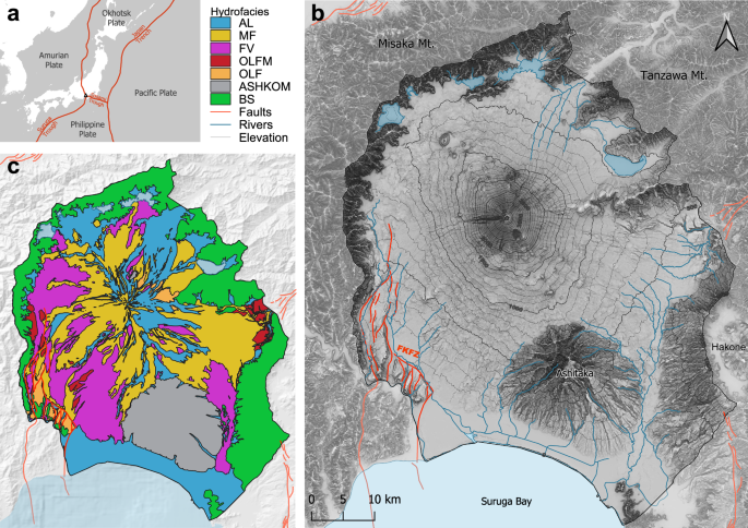
Hydrological Network: Data from national maps provided river and lake information at a scale of 1:25,000. This model omits anthropogenic modifications for evaluating natural hydrodynamics.
-
Hydrofacies and Geological Data: Existing hydrofacies data from NHM was digitized for hydrostratigraphy, supplemented by geological maps, boreholes, and cross-sectional studies to ensure comprehensive coverage.
-
Fault Data: Information from Japan’s Active Fault Database was used to model the Fujikawa-Kako Fault Zone. Data suggest varying aquifer thickness influenced by the fault.
-
Land Use Data: The 2022 High-Resolution LULC Map was employed to define overland flow parameters using five generalized categories.
- Software Tools: The study utilized various software for GIS (QGIS), geological modeling (Aspen SKUA), mesh generation (AlgoMesh), and hydrological modeling (HydroGeoSphere).
Workflow Summary:
The workflow involved preprocessing data in GIS, generating a numerical mesh, constructing a 3D geological model, and integrating with hydrological models for simulations. Steps entailed defining domains, hydrogeological stratigraphy, and assigning hydraulic properties.
Model Construction and Simulation:
The model captures interactions between surface and subsurface flow, considering complexities of volcanic and hydrological features, while addressing computational efficiency. Calibration involved sensitivity analyses for hydraulic properties, emphasizing the importance of accurate permeability modeling.
Final Output:
The model aims to provide a robust framework for understanding groundwater dynamics and resource management under climate variability, with results prepared for visualization and analysis.
