

Close Menu
Terrain News
  • Environmental Science
  • Landforms & Habitats
  • Extreme Events
  • Watershed Restoration
  • Wildfire
What's Hot

Innovative Water Management Strategies for the Volcanic Watershed of Mt. Fuji

Chum Salmon Comeback: River Restoration Boosts Returns in Washington Watershed

Elevating Client Experience Through Innovative Solutions

Facebook X (Twitter) Instagram
Facebook X (Twitter) Instagram Pinterest
Terrain News
TerrainWorks
  • Environmental Science
  • Landforms & Habitats
  • Extreme Events
  • Watershed Restoration
  • Wildfire
Terrain News
You are at:Home»Watershed & Environmental Science»Innovative Water Management Strategies for the Volcanic Watershed of Mt. Fuji
Watershed & Environmental Science

Innovative Water Management Strategies for the Volcanic Watershed of Mt. Fuji

Terrain NewsBy Terrain NewsSeptember 2, 2026002 Mins Read
Share Facebook Twitter Pinterest LinkedIn Tumblr Email
Innovative Water Management Strategies For The Volcanic Watershed Of Mt.
Share
Facebook Twitter LinkedIn Pinterest Email

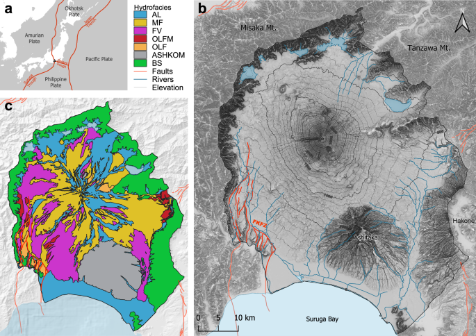
The article outlines the workflow for building 3D geological and hydrological models focusing on the Mt. Fuji catchment. Table 2 compiles various input data, including hydrofacies interfaces, surface topography, and hydrological parameters, with referenced URLs for access.

Key Components:

  1. Digital Elevation Model (DEM): The ASTER GDEM was utilized for surface topography, merged with GEBCO bathymetric data and lake information to depict the overall landscape accurately.

  2. Hydrological Network: Data from national maps provided river and lake information at a scale of 1:25,000. This model omits anthropogenic modifications for evaluating natural hydrodynamics.

  3. Hydrofacies and Geological Data: Existing hydrofacies data from NHM was digitized for hydrostratigraphy, supplemented by geological maps, boreholes, and cross-sectional studies to ensure comprehensive coverage.

  4. Fault Data: Information from Japan’s Active Fault Database was used to model the Fujikawa-Kako Fault Zone. Data suggest varying aquifer thickness influenced by the fault.

  5. Land Use Data: The 2022 High-Resolution LULC Map was employed to define overland flow parameters using five generalized categories.

  6. Software Tools: The study utilized various software for GIS (QGIS), geological modeling (Aspen SKUA), mesh generation (AlgoMesh), and hydrological modeling (HydroGeoSphere).

Workflow Summary:

The workflow involved preprocessing data in GIS, generating a numerical mesh, constructing a 3D geological model, and integrating with hydrological models for simulations. Steps entailed defining domains, hydrogeological stratigraphy, and assigning hydraulic properties.

Model Construction and Simulation:

The model captures interactions between surface and subsurface flow, considering complexities of volcanic and hydrological features, while addressing computational efficiency. Calibration involved sensitivity analyses for hydraulic properties, emphasizing the importance of accurate permeability modeling.

Final Output:

The model aims to provide a robust framework for understanding groundwater dynamics and resource management under climate variability, with results prepared for visualization and analysis.

Source link

Fuji Innovative Management Strategies Volcanic Water Watershed
Share. Facebook Twitter Pinterest LinkedIn Tumblr Email
Previous ArticleChum Salmon Comeback: River Restoration Boosts Returns in Washington Watershed
leebenda
Terrain News
  • Website

Related Posts

Chum Salmon Comeback: River Restoration Boosts Returns in Washington Watershed

September 2, 2026

Elevating Client Experience Through Innovative Solutions

September 1, 2026

Grant Awarded to Enhance Glass Recycling in Ada Through The Watershed Movement

September 1, 2026
Top Posts

Steamboat Secures $5 Million for River Revitalization

January 25, 202523 Views

Assessing Climate Change and Human Influence on Runoff in a South China Tropical Watershed

February 3, 202520 Views

Harnessing Machine Learning to Enhance Extreme Weather Alerts

January 8, 202520 Views
Stay In Touch
  • Facebook
  • YouTube
  • TikTok
  • WhatsApp
  • Twitter
  • Instagram
Most Popular

Steamboat Secures $5 Million for River Revitalization

January 25, 202523 Views

Assessing Climate Change and Human Influence on Runoff in a South China Tropical Watershed

February 3, 202520 Views

Harnessing Machine Learning to Enhance Extreme Weather Alerts

January 8, 202520 Views
Don't Miss

Innovative Water Management Strategies for the Volcanic Watershed of Mt. Fuji

Chum Salmon Comeback: River Restoration Boosts Returns in Washington Watershed

Elevating Client Experience Through Innovative Solutions

Popular This Week

Federal Wildlife Officer Presumed Lost in Oklahoma Wildfire

Empowering Kids to Safeguard Canandaigua Lake at Science Camp

Celebrating 30 Years of Innovative Watershed Internship Program with NYC DEP Leaders

© 2026 Terrain News. All Rights Reserved.
  • About Us
  • Privacy Policy
  • Terms and Conditions
  • Disclaimer

Type above and press Enter to search. Press Esc to cancel.