

Close Menu
Terrain News
  • Environmental Science
  • Landforms & Habitats
  • Extreme Events
  • Watershed Restoration
  • Wildfire
What's Hot

Wildfire Threat Near Battle Ground Triggers Urgent Evacuations

Conservation Grants Now Available for Appalachian Ohio

Wildfire Threat Forces Tens of Thousands to Evacuate Reno, Nevada

Facebook X (Twitter) Instagram
Facebook X (Twitter) Instagram Pinterest
Terrain News
TerrainWorks
  • Environmental Science
  • Landforms & Habitats
  • Extreme Events
  • Watershed Restoration
  • Wildfire
Terrain News
You are at:Home»Watershed & Environmental Science»Transforming SWAT for Eco-Hydrological Insights in Arid Grasslands
Watershed & Environmental Science

Transforming SWAT for Eco-Hydrological Insights in Arid Grasslands

Terrain NewsBy Terrain NewsFebruary 21, 2025002 Mins Read
Share Facebook Twitter Pinterest LinkedIn Tumblr Email
Transforming Swat For Eco Hydrological Insights In Arid Grasslands
Share
Facebook Twitter LinkedIn Pinterest Email

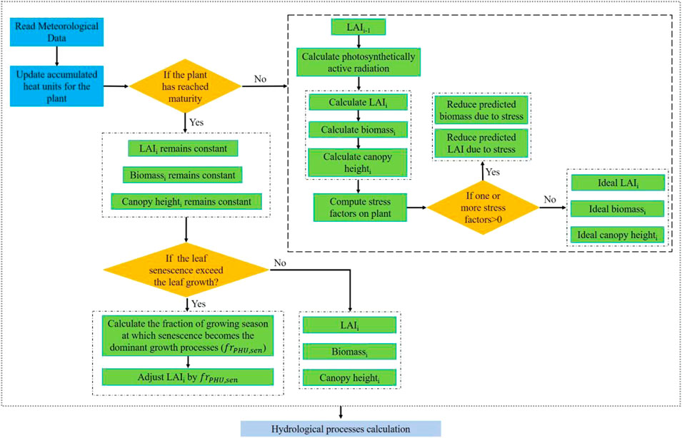
Grasslands are vital ecosystems in arid and alpine regions, influenced by terrain, climate change, and human activities. Different vegetation coverages affect eco-hydrological processes, making it crucial to include vegetation coverage in hydrological models like the Soil and Water Assessment Tool (SWAT). However, SWAT faces limitations in modeling plant growth due to an oversimplified land use classification and a uniform leaf area index (LAI) calculation that doesn’t account for site-specific variations.

To tackle these issues, the study aims to enhance SWAT’s performance by integrating high-resolution, remotely sensed LAI data based on the Global Land Surface Satellite (GLASS) and Landsat imagery. This leads to capturing the diverse vegetation coverages accurately. The application focuses on the Bayin River watershed, a typical arid region in the Qinghai-Tibet Plateau, where vegetation comprises primarily grasslands.

Methodologically, land use was classified using Landsat imagery, and the modified model’s performance was validated against site-specific data for streamflow, sediment yield, and evapotranspiration (ET). Results demonstrated that the modified SWAT, which incorporated the high-resolution LAI, significantly improved the simulations of streamflow and sediment yields compared to the original model. Enhanced accuracy in model predictions was also observed in ET simulations, confirming that incorporating high-quality, spatially heterogeneous LAI is vital for effective eco-hydrological modeling.

Overall, this study illustrates the potential of utilizing remotely sensed data to refine hydrological models, particularly in regions undergoing ecological changes due to climate impacts and restoration efforts. The findings highlight the importance of accurate vegetation dynamics in hydrological simulations for effective environmental management and planning.

Source link

Arid EcoHydrological Grasslands Insights SWAT Transforming
Share. Facebook Twitter Pinterest LinkedIn Tumblr Email
Previous ArticlePrepare for Unpredictable Weather This Holiday Season
Next Article La Pine Residents Rally Against Wildfire Hazard Map
leebenda
Terrain News
  • Website

Related Posts

Innovative Neighborhood Rain Catchers Promote Watershed Conservation Education

August 10, 2026

Chesapeake Bay Health Shows Remarkable Recovery Over Time

August 9, 2026

Watershed Meeting for Salem, Haverhill, and Atkinson Residents

August 8, 2026
Top Posts

Steamboat Secures $5 Million for River Revitalization

January 25, 202523 Views

Assessing Climate Change and Human Influence on Runoff in a South China Tropical Watershed

February 3, 202519 Views

Impact of Glacier Retreat on Land Use and Ecosystem Services in High Andes

February 3, 202519 Views
Stay In Touch
  • Facebook
  • YouTube
  • TikTok
  • WhatsApp
  • Twitter
  • Instagram
Most Popular

Steamboat Secures $5 Million for River Revitalization

January 25, 202523 Views

Assessing Climate Change and Human Influence on Runoff in a South China Tropical Watershed

February 3, 202519 Views

Impact of Glacier Retreat on Land Use and Ecosystem Services in High Andes

February 3, 202519 Views
Don't Miss

Wildfire Threat Near Battle Ground Triggers Urgent Evacuations

Conservation Grants Now Available for Appalachian Ohio

Wildfire Threat Forces Tens of Thousands to Evacuate Reno, Nevada

Popular This Week

Funding Boost for Pecos River Restoration and Wildlife Recovery Initiative

Wildfire Threat Forces Tens of Thousands to Evacuate Reno, Nevada

Colorado West Land Trust Unveils Exciting Restoration Plan for North Fork Watershed Project

© 2026 Terrain News. All Rights Reserved.
  • About Us
  • Privacy Policy
  • Terms and Conditions
  • Disclaimer

Type above and press Enter to search. Press Esc to cancel.