Close Menu
Terrain News
  • Environmental Science
  • Landforms & Habitats
  • Extreme Events
  • Watershed Restoration
  • Wildfire
What's Hot

Columbia County Secures Grant for Watershed Restoration

Cyprus Hosts Successful Hackathon Spotlighting Innovative Wildfire Solutions

Farmers Insurance Proposes 7% Rate Increase While Committing to 5% Policy Growth in Wildfire Areas

Facebook X (Twitter) Instagram
Facebook X (Twitter) Instagram Pinterest
Terrain News
TerrainWorks
  • Environmental Science
  • Landforms & Habitats
  • Extreme Events
  • Watershed Restoration
  • Wildfire
Terrain News
You are at:Home»Wildfire»Innovative Sandbox Technology Enhances Wildfire Training for Colorado Firefighters
Wildfire

Innovative Sandbox Technology Enhances Wildfire Training for Colorado Firefighters

Terrain NewsBy Terrain NewsApril 2, 2025011 Min Read
Share Facebook Twitter Pinterest LinkedIn Tumblr Email
Innovative Sandbox Technology Enhances Wildfire Training For Colorado Firefighters
Share
Facebook Twitter LinkedIn Pinterest Email

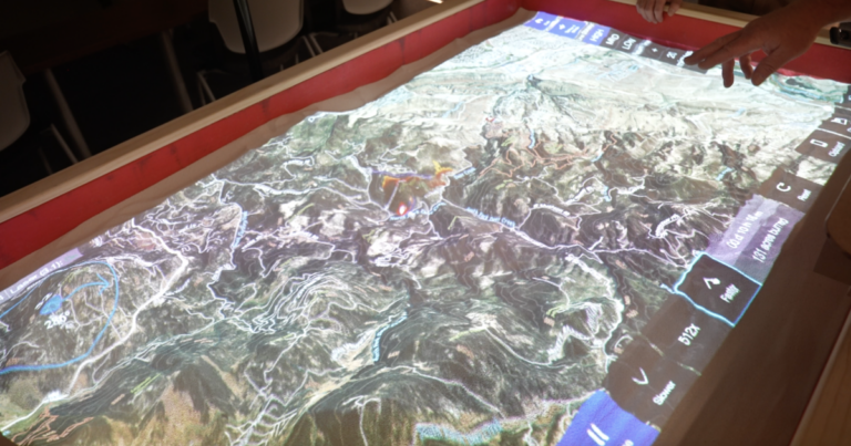
Colorado firefighters are enhancing their wildfire training using a new technology called the SimTable, funded by a Homeland Security grant. This $100,000 high-tech sandbox allows first responders to simulate real-time wildfire scenarios, improving training realism compared to traditional methods. Brian Keating, fire management officer at the Jefferson County Sheriff’s Office, explained that the SimTable uses elevation data and Google Earth imagery to create landscapes where firefighters can adjust variables like wind speed to see how they affect fire growth. The Jefferson County Sheriff’s Office sees the SimTable not only as a training tool but also as a way to educate homeowners about wildfire mitigation efforts. A joint training event is scheduled for mid-April with various agencies to further these goals.

Source link

Colorado Enhances Firefighters Innovative Sandbox Technology Training Wildfire
Share. Facebook Twitter Pinterest LinkedIn Tumblr Email
Previous ArticleMapping Alpine Snow Depth and Volume Using Aerial Imagery Techniques
Next Article Share Your Thoughts on the Trinity River Watershed Plan
leebenda
Terrain News
  • Website

Related Posts

Cyprus Hosts Successful Hackathon Spotlighting Innovative Wildfire Solutions

November 26, 2025

Farmers Insurance Proposes 7% Rate Increase While Committing to 5% Policy Growth in Wildfire Areas

November 25, 2025

LA Wildfire Relief Drive Brings Hope and Support to Victims

November 22, 2025
Top Posts

Harnessing Machine Learning to Enhance Extreme Weather Alerts

January 8, 202519 Views

Steamboat Secures $5 Million for River Revitalization

January 25, 202517 Views

Understanding Extreme Weather: The Link to the Climate Crisis

January 8, 202515 Views
Stay In Touch
  • Facebook
  • YouTube
  • TikTok
  • WhatsApp
  • Twitter
  • Instagram
Most Popular

Harnessing Machine Learning to Enhance Extreme Weather Alerts

January 8, 202519 Views

Steamboat Secures $5 Million for River Revitalization

January 25, 202517 Views

Understanding Extreme Weather: The Link to the Climate Crisis

January 8, 202515 Views
Don't Miss

Columbia County Secures Grant for Watershed Restoration

Cyprus Hosts Successful Hackathon Spotlighting Innovative Wildfire Solutions

Farmers Insurance Proposes 7% Rate Increase While Committing to 5% Policy Growth in Wildfire Areas

Popular This Week

Global Cost of Natural Disasters Surpasses $250 Billion in 2023, Reports German Insurer

App Tool Measures Pesticide Toxicity Levels

Killeen Celebrates Bravery of Firefighters Who Aided in California Wildfires

© 2025 Terrain News. All Rights Reserved.
  • About Us
  • Privacy Policy
  • Terms and Conditions
  • Disclaimer

Type above and press Enter to search. Press Esc to cancel.