
Close Menu
Terrain News
  • Environmental Science
  • Landforms & Habitats
  • Extreme Events
  • Watershed Restoration
  • Wildfire
What's Hot

Enhanced Watershed Management: Prioritizing Kiltie Micro-Watershed in Ethiopia Through Morphometric Analysis and Weighted Sum Techniques

Innovative Solutions for Client Success

St. Croix Watershed Research Station Launches Summer 2018 Artist and Writer Residencies

Facebook X (Twitter) Instagram
Facebook X (Twitter) Instagram Pinterest
Terrain News
TerrainWorks
  • Environmental Science
  • Landforms & Habitats
  • Extreme Events
  • Watershed Restoration
  • Wildfire
Terrain News
You are at:Home»Watershed & Environmental Science»Enhanced Watershed Management: Prioritizing Kiltie Micro-Watershed in Ethiopia Through Morphometric Analysis and Weighted Sum Techniques
Watershed & Environmental Science

Enhanced Watershed Management: Prioritizing Kiltie Micro-Watershed in Ethiopia Through Morphometric Analysis and Weighted Sum Techniques

Terrain NewsBy Terrain NewsAugust 2, 2026012 Mins Read
Share Facebook Twitter Pinterest LinkedIn Tumblr Email
Enhanced Watershed Management: Prioritizing Kiltie Micro Watershed In Ethiopia Through Morphometric
Share
Facebook Twitter LinkedIn Pinterest Email

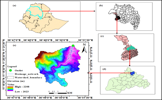
The article discusses an analysis of morphometric parameters in a watershed, utilizing Digital Elevation Models (DEM), remote sensing, and ArcGIS to evaluate surface development and soil erosion risks. It categorizes morphometric parameters into four types: linear, areal, shape, and relief, to identify areas vulnerable to soil erosion—crucial for effective mitigation strategies.

Linear Parameters: This involves stream characteristics like order, number, length, and bifurcation ratio. Higher linear parameter values indicate increased erosion risk and reflect the watershed’s morphology. The study used Strahler’s method for stream ordering, revealing various micro-watersheds of different stream orders.

Areal Parameters: Parameters such as drainage density (Dd), stream frequency (Fs), and drainage texture (Dt) were analyzed to highlight erosion risks. High values in these metrics correlate with greater runoff potential and increased erosion.

Shape Parameters: This section discusses geometric features (e.g., form factor, elongation ratio) with inversely proportional relationships to soil erosion. For instance, elongated shapes are more susceptible to erosion due to increased surface runoff.

Relief Parameters: These include elevation and ruggedness, which directly relate to erosion potential. Higher relief indicates increased susceptibility to erosion and less infiltration.

The article emphasizes that a multi-faceted approach to watershed prioritization enhances the accuracy of identifying erosion-prone areas. The weighted sum priority (WSP) method helped rank watersheds according to their erosion risk, revealing that approximately 78% of the studied area faces a very high risk of soil erosion.

The findings suggest urgent implementation of soil and water conservation practices, including terraces and reforestation, targeting high-risk micro-watersheds to mitigate erosion effectively. These strategies are crucial for sustainable management of the Kiltie watershed and offer a framework adaptable for other regions facing similar challenges.

Source link

Analysis Enhanced Ethiopia Kiltie Management MicroWatershed Morphometric Prioritizing Sum Techniques Watershed Weighted
Share. Facebook Twitter Pinterest LinkedIn Tumblr Email
Previous ArticleInnovative Solutions for Client Success
leebenda
Terrain News
  • Website

Related Posts

St. Croix Watershed Research Station Launches Summer 2018 Artist and Writer Residencies

August 1, 2026

Watershed Restoration Plan Discussion at Ventura River Meeting on August 6

August 1, 2026

Chesapeake Bay Report: Watershed Earns C Grade

July 31, 2026
Top Posts

Steamboat Secures $5 Million for River Revitalization

January 25, 202523 Views

Assessing Climate Change and Human Influence on Runoff in a South China Tropical Watershed

February 3, 202519 Views

Harnessing Machine Learning to Enhance Extreme Weather Alerts

January 8, 202519 Views
Stay In Touch
  • Facebook
  • YouTube
  • TikTok
  • WhatsApp
  • Twitter
  • Instagram
Most Popular

Steamboat Secures $5 Million for River Revitalization

January 25, 202523 Views

Assessing Climate Change and Human Influence on Runoff in a South China Tropical Watershed

February 3, 202519 Views

Harnessing Machine Learning to Enhance Extreme Weather Alerts

January 8, 202519 Views
Don't Miss

Enhanced Watershed Management: Prioritizing Kiltie Micro-Watershed in Ethiopia Through Morphometric Analysis and Weighted Sum Techniques

Innovative Solutions for Client Success

St. Croix Watershed Research Station Launches Summer 2018 Artist and Writer Residencies

Popular This Week

Rain Barrels: A Sustainable Solution for Water Conservation

Join the 2026-27 AmeriCorps Watershed Ambassadors Program with DEP

Revitalizing Lower Mammoth Creek: A Community-Driven Restoration Vision

© 2026 Terrain News. All Rights Reserved.
  • About Us
  • Privacy Policy
  • Terms and Conditions
  • Disclaimer

Type above and press Enter to search. Press Esc to cancel.